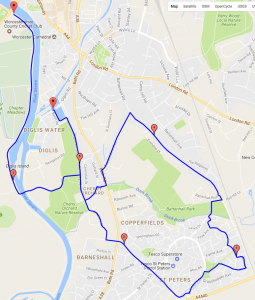
Distance: 5.4 miles;
Hills: steep uphill to start, downhill section at the end – much gentler than the start and on a good quality wide and relatively quiet road. 100 metres difference between highest and lowest point.
Traffic: *** generally quiet;
Surface Quality: ** varies – cycle paths through St. Peters are very rough, estate roads and Timberdine avenue have good surfaces;
Date: 15/1/2017
 This route involves cycle paths and quiet roads. It starts with a very steep uphill section from Diglis to Bath road. After that the gradients are much gentler. You get nice views across Worcester and towards the Malverns from Battenhall road. The cycle paths can be very rough – so quiet estate roads are often a better option. You lose height much more gently on Timberdine avenue. Finish with a cup of tea at the tea barge in Diglis basin.
Map: http://gmap-pedometer.com/?r=7008198
Worcester United Kingdom