Start and finish point: Elgar Statue, Cathedral Square, Worcester
Distance: 5.5 miles;
Hills: plenty – we avoid the steepest!;
Traffic: *** generally quiet;
Surface Quality: ** varies – some pretty rough – e.g Stanley Road, also some nice smooth sections – e.g. on Battenhall Road.
Date updated: 14th April 2018
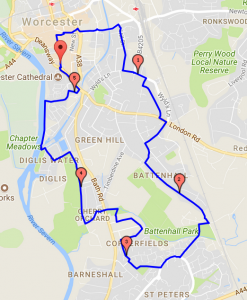 We start at the Elgar statue in Cathedral Square. Skate through the city centre along the pedestrianised high street, right down past Argos and to the Cornmarket and then make our way up Tallow Hill turning right down Hill Street – Stanley Road. This street is fairly quiet, but has its ups and downs and the road surface is fairly rough: the pavement is a viable option for some of it.
We turn left up Wyld’s lane and then up Victoria Avenue via Albert Road. Much of the road – and pavement – surface here is quite smooth. We get to London road on the level, take a left and then first right down Sebright Avenue: we’re going against the traffic for some of this – so need to be on the pavement/get out of the way if any vehicle comes from the opposite direction.
We skate through to Battenhall Road – joining it where the surface is pretty good – it’s also a wide road with not a lot of traffic on it and some nice views towards the Malverns.
We then follow cycle paths towards St.Peters, onto St. Peter’s Drive and take another cycle path towards Aldersey Road. We skate through quiet streets losing height and ending up at Bath Road Park. We cross Bath Road and then quiet streets along by Diglis Fields.
We join the river near Diglis Basin, skating alongside the river to the boat shaped building. Possibilities of seeing some bats near here. We then meander back up to the Elgar Statue.
Map: https://gmap-pedometer.com/?r=7225612
General Comments About Joining This Skate
- You skate entirely at your own risk;
- You need to be able to stop, turn, and control your speed – including on downhill sections;
- There are some rough surfaces that some skaters may find challenging;
- We don’t leave anyone behind!
To see when/if the skate is running, check out: https://www.facebook.com/groups/worcesterskaters/
Distance: 5.4 miles;
Hills: steep uphill to start, downhill section at the end – much gentler than the start and on a good quality wide and relatively quiet road. 100 metres difference between highest and lowest point.
Traffic: *** generally quiet;
Surface Quality: ** varies – cycle paths through St. Peters are very rough, estate roads and Timberdine avenue have good surfaces;
Date: 15/1/2017
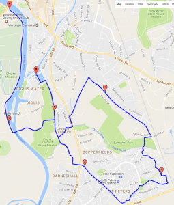 This route involves cycle paths and quiet roads. It starts with a very steep uphill section from Diglis to Bath road. After that the gradients are much gentler. You get nice views across Worcester and towards the Malverns from Battenhall road. The cycle paths can be very rough – so quiet estate roads are often a better option. You lose height much more gently on Timberdine avenue. Finish with a cup of tea at the tea barge in Diglis basin.
Map: http://gmap-pedometer.com/?r=7008198
Information
Distance: 22.1 miles;
Hills: a hill or two at the beginning (and end), long flat section along the River Pang
Traffic: *** generally quiet;
Surface Quality: ** generally good – some rough parts;
Date: 10/12/2011.
Route
Going south from the station, we took the second through road on the right off the A340 – this is much quieter than the first road leading out to the west which goes through Upper Basildon. As soon as we had left the A road the road climbs steeply – also quite slippy with rotting leaves – so could be hard to get a good push. After this the road undulates until, having gone under the M4 motorway, is lovely and flat as it follows the river Pang. This was followed by some more undulation finishing at the pub in Hampstead Norreys (where we had been before). There is a great community atmosphere in this pub – the postman arrived to deliver some Christmas mail, and we kept coming across him on our skate back as he visited farms and villages Postman Pat style along the route.
Map

Information
Distance: 28 miles;
Hills: Moderately hilly, long flat section at the beginning of the second half of the skate;
Surface Quality: ** generally good – some rough parts;
Traffic: ** mostly quiet but the odd busy/fast road;
Time: Start: 10.15, Lunch: 12.30-1.30, Reading: 4.30pm;
Date: 24th July 2011.
Route
 The route starts with an uphill stretch out of Pangbourne, with some traffic. We turn right at the village of Upper Basildon, onto a road which is much quieter. The route flattens out and we have nice views from the lane. Continue to Aldworth which had an old fashioned feel – perhaps it was the little 1930s car parked out in the street. Shortly afterwards, we take a cool leafy lane, down hill, towards Hampstead Norreys.
At Hampstead Norreys we stop in the White Hart for lunch. One of us has a steak, and the other had a roasted vegetable baguette and chips – suitably filling!
A couple of miles further on and the road flattens out – and we had several miles of flat skating alongside the river Pang – wonderful!
A mile before Tidmarsh, we could have headed back up to Pangbourne, but instead decided to carry on until Reading. A steep and busy hill just beyond Tidmarsh would have taken us into the back streets of Reading – but we didn’t fancy that. An idea was to take a gravel track and then a footpath up the hill (on foot) to avoid this hill – but due to some miscommunication we ended up going all the way down the track reaching the A4 – M4 junction. We then followed the A4 into Reading – some of it had a good cycle track – in other parts a very narrow pavement – with bushes that could have done with a trim. This final stretch wasn’t particularly pleasant – so returning to Pangbourne as originally planned would probably have been better.
Full route details.
Information
Distance: 5.5 miles;
Hills: nearly all flat;
Traffic: *** none/virtually none: all on pavement or through the city – which has very little traffic at the weekend;
Surface Quality: *** generally good.
Route
This is the description of the occasional Pre ESS (Pre Easy Saturday Skate) which happens from time to time on Saturday mornings. Check or post on the Easy Saturday Skate Facebook page if you want to do this skate.
We start at Liverpool Street station – by the clock at Bishopsgate, at 9.15am on Saturday morning to skate to the Easy Saturday Skate in Battersea Park. This is a lovely skate which usually takes about an hour – and is mostly (or all if you like) on pavements.
We start off skating through the City, and being a Saturday there is very little traffic. We join the Thames Path on the North Embankment just west of Southwark Bridge. The rest of the skate is along the river – except for a bit where we divert onto Whitehall from Embankment Station to avoid some of the people congestion on the approach to the houses of parliament.
We don’t race, and so we won’t leave you behind! But, you must be comfortable skating on and off pavements (we do a lot of that), and stopping of course.
To check if anyone else is going on a particular Saturday – check out the Easy Saturday Skate Facebook page – or put in a comment there if you are.
Map

Information
Distance: varies;
Hills: hilly – but nothing too big;
Traffic: ** generally quiet;
Surface Quality: ** varies;
Refreshments: lots of good pubs, also occasional tea shops.
Details
Hertfordshire has great options for country lane skating. One option is to start and finish in Knebworth. The road surfaces are of variable quality: the more minor roads can surprisingly have smoother surfaces than say a B road (perhaps they are made a bit rougher to improve stopping for those using tyres!). There are many quiet roads (particularly the yellow ones on Ordnance Survey maps): and as horse riding and cycling are common in this area this appears to make drivers more cautious.
Example routes:
http://www.gmap-pedometer.com/?r=3259569 (23 miles). http://www.gmap-pedometer.com/?r=5109787 (32 miles). See also: http://littlegreenride.blogspot.com/ for ideas – this was a regular cycling group – but the routes they did are generally also good for skating.
Information
Distance: 21 miles;
Hills: moderately hilly;
Surface Quality: * generally poor – some lanes had gravel/grass in the centre, making it impossible to do a full stride;
Traffic: *** mostly quiet;
Time: Start: 10.50, Lunch: 12.30-1.30, Back at Goring: 4.30pm;
Date: 22nd October 2011.
Route
The route was generally very quiet and very attractive. We left Goring through a private housing development – where the road quickly became very rough. After this, the route went through open countryside (no hedgerows), and we had lovely views across Oxfordshire and Berkshire. Lunch stop was at the The Black Horse near Stoke Row – very lovely, though limited choice of lunch (baguettes). The roads were often difficult to skate, though there was also very limited traffic.
Map


